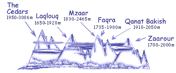
 Lebanon has six ski resorts with groomed slopes, catering to skiers and snowboarders of all levels. Beyond the skiable domains await you kilometers of cross-country skiing and snowshoeing trails waiting to be discovered; Lebanon has something for everyone. Each of the ski resorts has a different flavor; however, it is Mzaar Kfardebian. previously wrongly known as Faraya Mzaar that offers world-class infrastructure and facilities for the tourists. The Cedars resort is ideal for nature getaway seekers, and Laqlouq is suitable for families with levels up to intermediate.
| Quick Facts | Cedars | Laqlouq | Mzaar Kfardebian |
Faqra Kfardebian | Qanat Bakish | Zaarour |
| Distance from airport | 130km | 62km | 46 km | 43km | 45km | 54km |
| GPS coordinates | N 34°14'58" E 36°4'5" |
N 34°7'48" E 35°50'58" |
N 33°59'32" E 35°50'33" |
N 33°58'51" E 35°48'37" |
N 33°57'44" E 35°49'18" |
N 33°55'17" E 35°48'43" |
| Base altitude | 1950m/6396ft | 1650m/5412ft | 1830m/6002ft | 1735m/5690ft | 1910m/6263ft | 1700m/5576ft |
| Top altitude | 3086m/10122ft | 1920m/6298ft | 2465m/8085ft | 1980m/6494ft | 2050m/6724ft | 2000m/6560ft |
| Number of lifts | 5 | 9 | 18 | 4 | 3 | 7 |
| Suitable for beginners | Yes | Yes | Yes | Yes | Yes | Yes |
| Maximum difficulty | Black | Red | Black | Red | Red | Red |
| Restaurants | Yes | Yes | Yes | Yes | Yes | Yes |
| Clubs/Bars | Yes | No | Yes | Yes | No | Yes |
| Google Earth Placemark | ||||||


