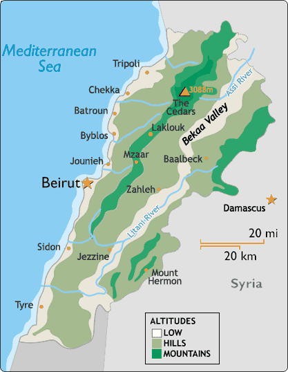
 Lebanon is located on the eastern edge of the Mediterranean. It is 212 km at its longest point and 85 km from east to west at its widest. Covering an area of only 10, 452 square kilometers, it is one of the world's smallest countries.
However, what it lacks in size certainly makes up for in geographical diversity. Contained within its borders are four different topographical areas: a narrow coastal plain, the inland peaks of Mount Lebanon where all ski resorts are located, the Bekaa plateau and the Anti-Lebanon range. With such a divergent topography, it's not surprising that temperature and weather conditions can vary widely from place to place at any one time. Short distances also make for a unique identity. Lebanese are always quick to tell visitors that it is possible to ski in the morning and swim in the afternoon. Why don't you impress your friends by having a go at this ;)
The narrow coastal plain, only 6.5 km at its widest point, rises steeply to the Mount Lebanon range. It is heavily urbanized and contains the major cities of Beirut, Tripoli and Sidon. The weather is hot and steamy in the summer, when humidity can reach 90%, with temperatures reaching over 30 degrees Celsius during July and August. Most of the rain, which comes in dramatic bursts, falls in January, February and March, when it can be quite cold. During spring and autumn, the weather is pleasant on the coastal plain with temperature hovering between 20 and 25 degrees Celsius.
The Mount Lebanon range, running parallel to the coastline, reaching 3000 meters at its highest point, experiences a typically Alpine climate, with plenty of snow and sub zero temperatures on the peaks during winter. In spring the snow melts and flows into rushing rivers, providing Lebanon with one of the best supplies of fresh water in the Middle East. During April and May the waterfalls in the mountains are at their most spectacular.
In summer, Lebanon's mountains and their many resorts offer a welcome retreat for those escaping the heat of the coastal cities. The Bekaa valley, an inland plateau,situated 1,000 m above sea level, is sandwiched between the Mount and Anti-Lebanon ranges. The Bekaa (or Bequaa) is drier than the rest of Lebanon with more pronounced climatic extremes. Summers are hot and dry, while winters are cold and frosty. The Anti-Lebanon range is Lebanon's most easterly topographical zone and runs north-south, parallel with the Bekaa, forming a natural boundary with neighboring Syria. The range's highest peak is Mount Hermon at 2,814 m.


